English
The construction of high-standard farmland is a key initiative to consolidate and improve food production capacity and ensure national food security. The General Rules for the Construction of High-standard Farmland emphasizes that dynamic monitoring of farmland quality should be carried out after the completion of high-standard farmland, including farmland quality, soil moisture, pest monitoring and growth monitoring, and comprehensive tracking, investigation, analysis and evaluation of the utilization of high-standard farmland.
With "Jilin-1" satellite data as the core, combined with soil formula, soil nutrients, topography slope, crop phenology, vegetation spectrum and other information, we carry out arable land quality evaluation monitoring, sustainable use monitoring and arable land protection monitoring after the completion of high standard farmland, providing comprehensive supervision for the subsequent use and development of high standard farmland.
Land quality evaluation
The grade interval is divided into intervals of 2000kg/hm², and the area with the highest production potential is recorded as 5, in decreasing order, and the area with the lowest production potential is recorded as 1.
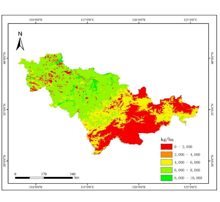
The overall trend of arable land quality score in Jilin Province is higher in the central part, followed by the western part and lower in the eastern part. This distribution pattern is determined by the climate characteristics of Jilin Province, topographic conditions, soil characteristics and other factors. Changchun and Siping are mainly plains with black soils, which are fertile and have high production potential. The average summer temperature is low, so the land quality score is low.
Analysis of maize suitability in Jilin Province
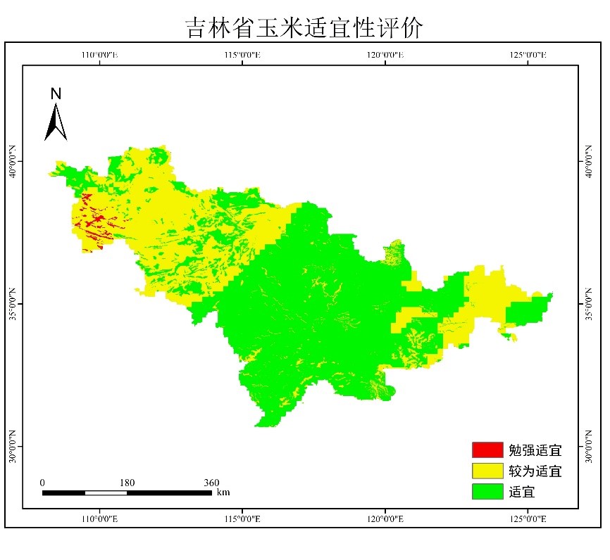
A hierarchical analysis model was constructed to calculate the suitability of maize growth in Jilin Province based on many factors such as elevation, slope, slope direction, annual rainfall, annual temperature, sunshine hours, soil nitrogen, phosphorus and potassium content, organic matter content, and soil pH. It was calculated that there was no unsuitable area in Jilin Province, and almost all areas in Jilin Province were suitable for cultivation.
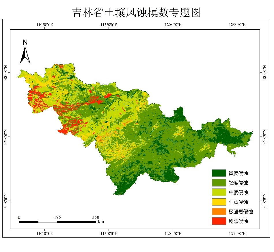
Soil erosion analysis
According to the standard, the maximum allowed erosion in northeast China is 200t/(km2*a). It is calculated that most areas in the eastern part of Jilin Province and some areas in the central part are light erosion. Most areas in the central and western parts are moderate erosion. Strong erosion and severe erosion exist in some areas in the west.
Monitoring of planting structure
Based on Jilin-1 remote sensing image to extract the spatial distribution of major crops in Lishu County in 2022, the extraction results are shown in the following figure.
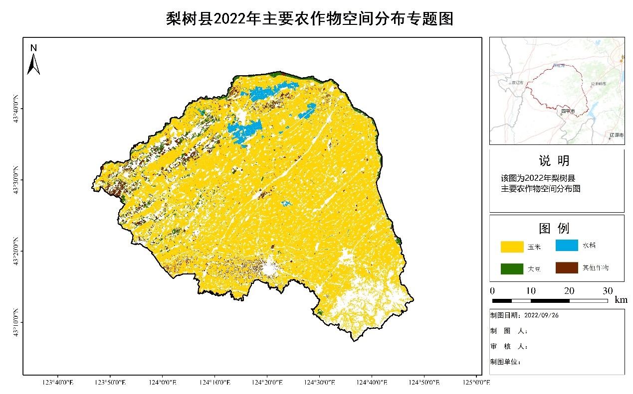
Spatial distribution of major crops in Lishu County in 2022
By calculating the area of vector results, we got that the percentage of crops sown in Li Shu County in 2022 was 89.65% for corn, 2.58% for rice, 3.70% for soybean and 4.07% for other crops.
Crop moisture monitoring
Based on the satellite image on May 3, the crop moisture monitoring of dry land in Lishu County was carried out, and the monitoring results are as follows:
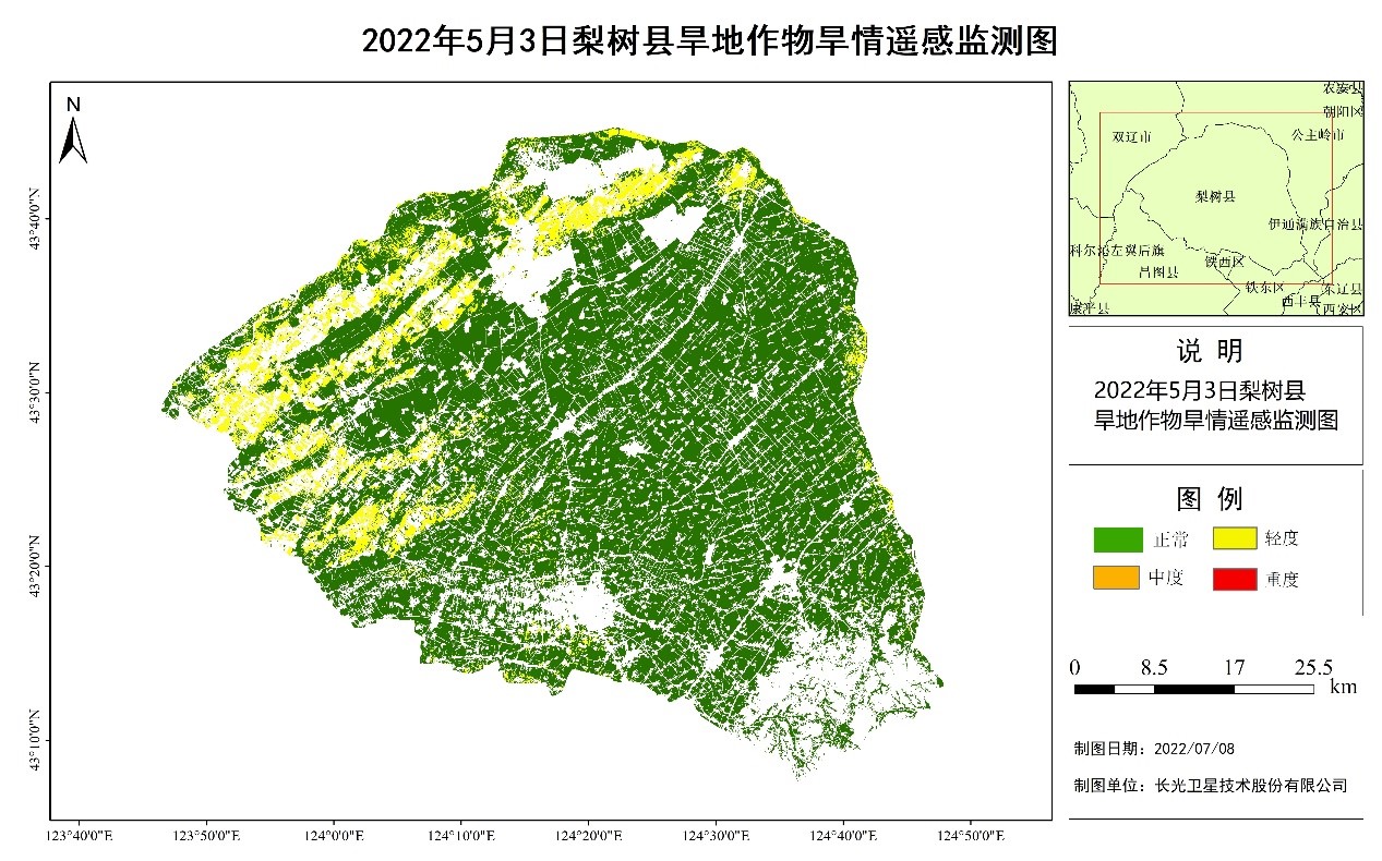
In early May, Lishu County, slightly higher temperatures, less precipitation, more sunshine. early May using satellite remote sensing data on May 3, Lishu County dryland crop monitoring, the results show that: most of the plots in the central and eastern areas of Lishu County moisture is good, the western and northern areas of Liujiakanzi town, Shen Yang town, small wide town and Linhai town part of the soil is mildly lack of moisture.
Crop growth monitoring
Based on the satellite image of June 26, 2022 and the historical satellite image of the same period, the analysis of dryland crop growth monitoring in Lishu County was carried out, and the monitoring results are as follows:
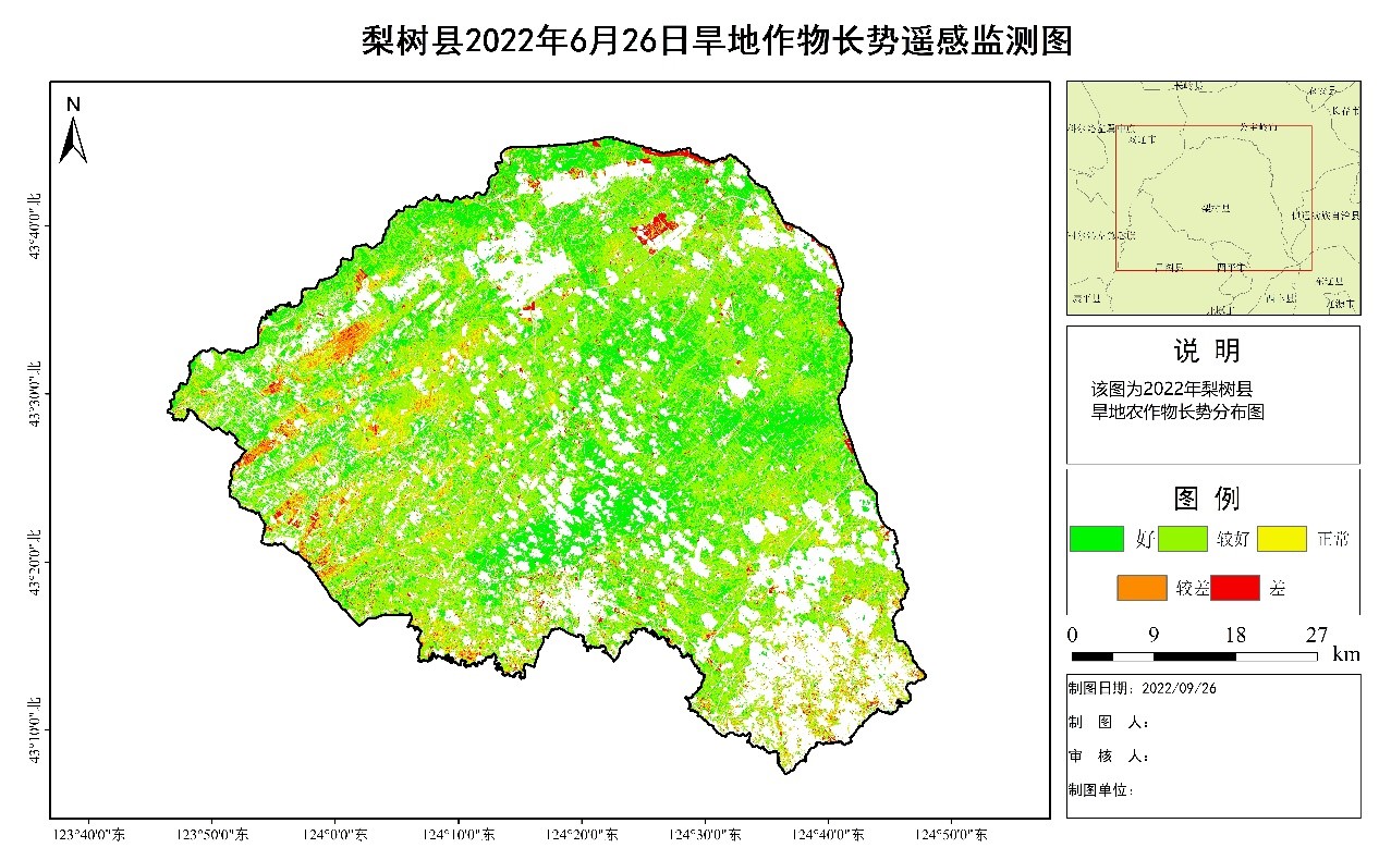
In June 2022, compared with the same period last year, the vast majority of corn in Lixue County was in good grade, mainly in the eastern region; a very small portion was in poor grade, mainly in the western town of Liujiatanzi, Shen Yang and Linhai. Statistically, the area of dry land with good grade is 37.76%, the area with better grade is 36.04%, the area with normal grade is 20.3%, the area with poor grade is 4.66%, and the area with poor grade is 1.24%.
Crop yield estimation
The physiological, biochemical, farm environment and meteorological data of several key fertility stages of maize in Lishu County were collected, the synchronized Jilin-1 spectral star data were obtained, the leaf area index was obtained by inversion of PROSAIL radiative transfer model, and the rapid yield mapping of maize in Lishu County was carried out with the help of SCYMC regional scale yield estimation model, and the monitoring results are as follows.
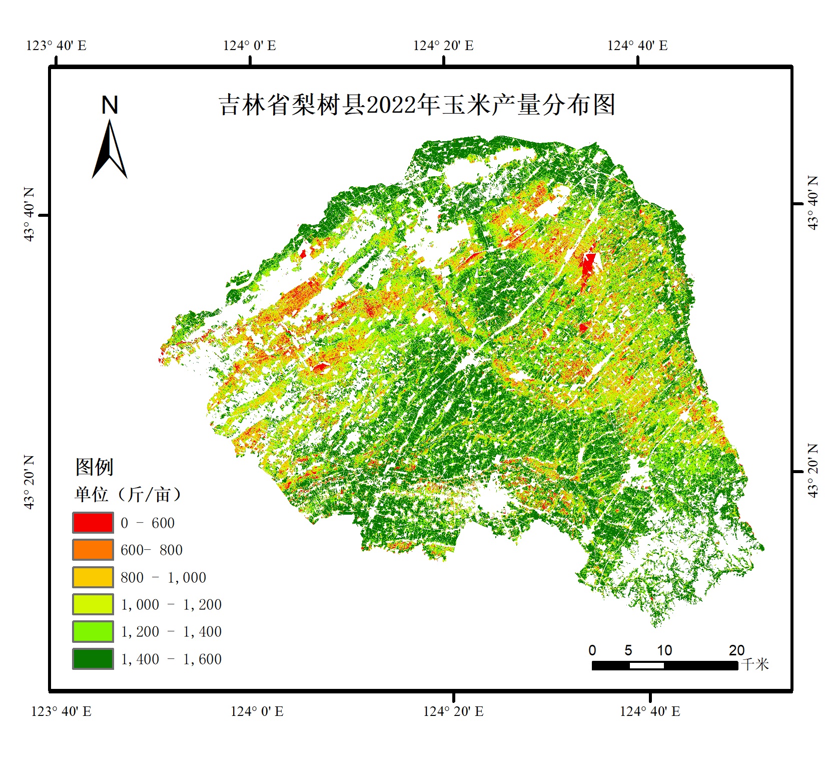
The estimation results show that the corn yield of the vast majority of plots in Li Shu County in 2022 is at a high level, basically above 1000 kg/mu. However, the yield of a few plots is lower than 600 jins/mu or even extinct due to the flooding in July.
Non-agriculturalization of farmland
With Jilin-1 high-resolution satellite images as the data source, information on illegal occupation of arable land is extracted from the central city of Changchun and the key areas of 17 counties (cities) districts and development zones in the city. Through statistical analysis and comprehensive mapping of monitoring data, remote sensing monitoring of illegal occupation of arable land in key areas of Changchun is carried out, which provides a strong guarantee for relevant departments in Changchun to strengthen protection and comprehensive control of arable land. Examples of remote sensing monitoring of illegal occupation of arable land in Changchun City are shown below.
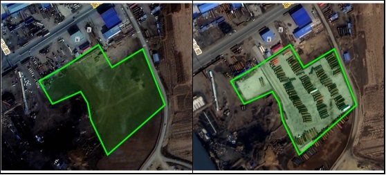
Non-foodification of cropland
Using the high-resolution satellite image data, we extracted and verified the "non-food" plots in the monitoring area, and based on the experimental results of the "non-food" plot verification method, we completed the Based on the experimental results of the verification method of "non-food" plots, we completed the extraction, production of thematic maps and statistical analysis of "non-food" plots in Gongpo Township, Hainan Province.
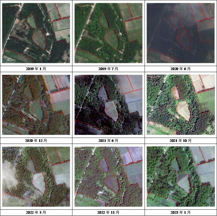
The satellite images were procured and pre-processed, and the distribution and area of "non-food" land in Gongpo Township were extracted by remote sensing technology, and the data were accurate to the field; the monitoring frequency was once a year. According to the monitoring results, the "non-food" plots are distributed in the whole town of Gongpo, and the extracted plots are basically in line with the actual situation according to the on-site verification points, and the accuracy meets the demand. The following is the time series map of two "non-food" plots. From the time series image, it can be seen that the arable land in the plots has lost its arable land properties and no crops are grown.
